![]()
![]()
![]()
![]()
![]()
![]()
![]()
![]()
![]()
![]()
(Click on images for larger image)
One of the first tasks to be accomplished when opening a new frontier to settlement was surveying the land and mapping rivers, streams and trails. Some of the most notable early explorers were either surveyors or map-makers. George Washington and Daniel Boone were both land surveyors at one time or another in their careers and David Thompson, Peter Fidler, Peter Pond, Sir Alexander Mackenzie and Lewis and Clark collected survey data for map-making purposes.
During the weekend of August 6 – 8th, 2004 the Alaska Chapter of CoHT and Bad Company Brigade (the notorious “Bad Boys of the North”) joined forces to sponsor a historical trek with the objective of surveying currently unmapped trails using the same techniques as were used by eighteenth and early 19th century land surveyors and map-makers. This is a report of our adventure.
CoHT president and Nor’ West Company proprietor Thom “Swanny” Swan planned, organized and provisioned our expedition. He spent much of his free time for nearly six months researching historical land survey practices, acquiring or making necessary equipment, advertising the adventure among interested living history enthusiasts, and organizing the party. He chose the Jenny M Creek drainage near Two Rivers because the site is accessible by highway vehicles, contains trails that are not currently shown on USGS topographical maps, and happens to be one of his favorite moose hunting areas.
To plan the expedition Swanny noted that many historical survey parties were quite large and included not only the surveyor and chain carriers, but also ax men, scouts, hunters and camp keepers. For our historical experiment we recruited Kathy Waggoner as our camp keeper. Although we had recruited designated scouts they were unable to participate in the event. That was no major problem however, as scouts working for historical survey crews more than likely spent much of their time afield, well away from the other members of the party.
On Friday, August 6th Swanny, David “Music Man” Underwood and David’s 5 year old son Vance arrived at the designated campsite shortly after noon. They set up their tents in brutally hot weather (by Alaska standards) and whiled away the afternoon waiting for other members of the party to arrive. Dave spent much of the afternoon hunting red squirrels with his .54 caliber rifle with some success while Swanny reviewed historical survey methods in Samuel Wyld’s “The Practical Surveyor” and established the control point upon which the survey would be based in the center of a bridge crossing Jenny M Creek. He chose that site as his control point because it is well charted and was recently rebuilt so can be relied upon to remain present for many years in the future should others wish to conduct a survey based on that point in the future.
Swanny’s big dog, Chinook, signaled the arrival of Shawn “One Blanket” Kent and his 12 year old daughter Cheyenne and Kathy Waggoner. These members of the party did not arrive until later that evening, after Swan and the Underwoods had made their dinner of dried trail rations, basically a stew made up of boiled jerk, parched wild rice and dried squash.
Shawn and Kathy set up their tents in our camping area, Kathy organized her camp kitchen and the crew gathered around the cook fire to share beverages and good conversation well into the night. In fact, we had been in our beds only a couple of hours when “Wild Bill” Fox arrived from his home in Anchorage, at about 2 in the morning. Wild Bill proved an invaluable member of our crew as he has worked as a professional land surveyor in the past, so was able to teach us much that he had learned through real-world experience. While “book learning” is valuable it certainly does not replace practical experience.
In preparing for this trek Kathy had spent quite a lot of time researching foodways of North America’s early frontiers and had gone to great lengths to plan an authentic menu. We awoke at a reasonable hour Saturday morning to the smell of freshly brewed coffee and dug heartily into a large kettle or rockahominy, ground corn combined with maple sugar and boiled up as a mush. With our bellies full we organized our crew.
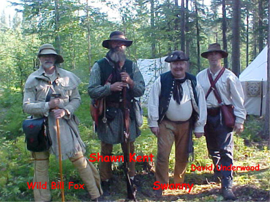 Our Survey Crew
Our survey crew consisted of Swanny, David, Shawn and Wild Bill. Vance and Cheyenne both elected to stay in camp to assist Kathy. Because Swanny organized the experiment he was designated the “surveyor” and the other three men as chain carriers. Historically chainmen were required to sign an oath swearing that they would do their utmost to take accurate measures and keep accurate records. After breakfast each of our chainmen were asked to sign a surveyor’s oath, copied from a document originating in 1740
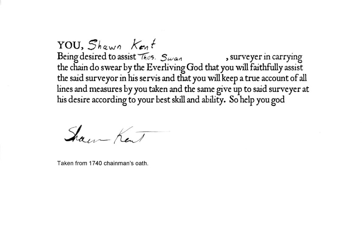
Chainman's Oath signed by Shawn "One Blanket" Kent
We knew that firearms would be an encumberence while trying to work, but we were in bear country, so Swanny tucked his .62 caliber flintlock pistol in his belt and Shawn carried his smoothbore fowler, loaded with a round ball, slung on his back. Had more men participated they would likely have served as “ax men” in a historical context, but also provided additional fire-power should we encounter an unhappy bear.
Our first step was to survey from our control point on the bridge to the main trail we would be mapping. The bridge is located just a bit to the west of the main trail, in a fork, so we measured the entire fork of the trail to gain some experience with our equipment before heading into the meat of the project. Wild Bill’s experience proved extremely valuable as he taught us the best places to place our staves in a curve in order to accurately measure and map bends or turns in a trail or road, and how to use the authentic surveyor’s compass to “shoot” our bearings. Since Bills’ reproduction compass was already fixed to a Jacob’s staff, we used his instrument rather than mine. This proved later to be a bit of a mistake which I’ll elaborate upon later in the report.
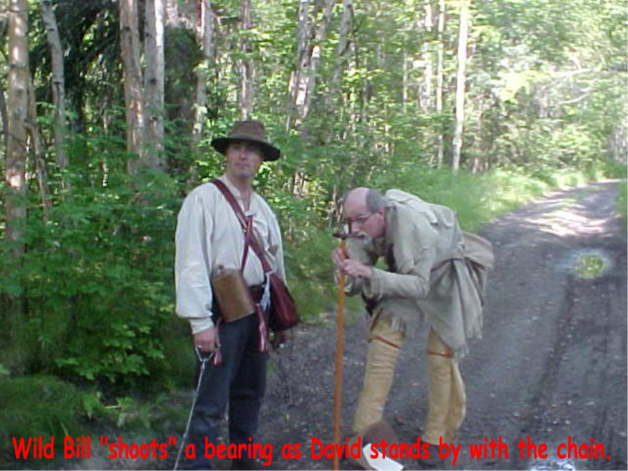
Wild Bill Shoots a Bearing while David stands by with the chain
Having measured the fork in the road we proceeded down the trail, shooting the bearings between stations marked with wooden staves and then measuring the distance using a 33 foot (two pole) surveyor’s chain. A full Gunter’s chain is 66 feet (four rods) but it was not uncommon for frontier surveyors to use the shorter two-pole chain as it is easier to manage in rough terrain or brush. We had only shot a couple of stations when we realized that our bearings did not seem to be true when compared to a pocket compass. All four us are reasonably well educated and reasonably intelligent people, but we were unable to figure out the cause of what appeared to be a fairly significant error. Finally we agreed on precisely how we would read the bearings.
We spent a consider amount of time mulling over the problem, even taking a break to eat a lunch of boiled-beef and cheese in the process, but were unable to identify the cause of the apparently inaccurate bearings, even after ruling out local magnetic attraction. Finally we determined that so long as we each read the bearings exactly the same way then we would at least be able to reconcile the error later, once we determined the cause of it. Having agreed to a standard operating procedure, we continued with our job.
For most of Saturday Swanny served as the lead man, marking the line to be surveyed with staves. Bill started out as the “instrument man” reading the bearings between stations and sighting through the sites (alidade) of the compass to ensure the chainmen did not deviate from the line as they measured the distance between the staves, and recording the bearings and distances in the field book. Later in the day he and David switched roles. The other two men served as chainmen, accurately measuring the distances between stations.
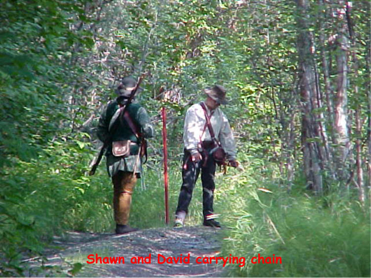
Shawn and David Carrying the Chain
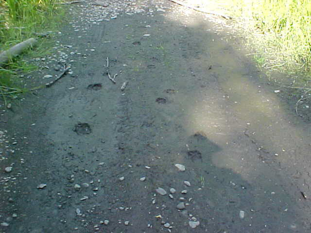
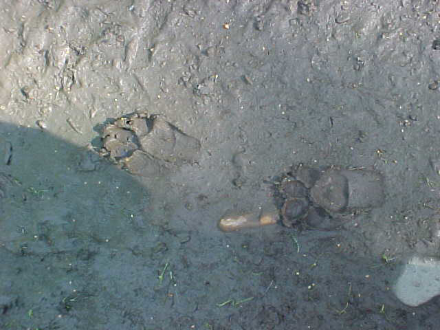
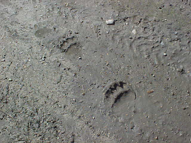
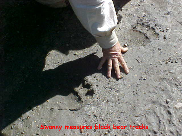
We had been working steadily for some time when Swanny, placing stakes well ahead of the others, observed a set of small moose tracks paralleled by a set of unusually large wolf tracks in the trail. Between the next two stations he observed a set of tracks left by a relatively large black bear. Both sets of tracks were reasonably fresh, certainly within the past 12 hours. The image on the left shows both the moose and wolf tracks, the one at left center is a detail of the wolf tracks, at right center the bear tracks and on the far right shows Swanny's hand in the bear tracks to add a sense of scale.
It was a very hot day, with temperatures in the mid-80s, but we worked steadily to advance the line finally reaching a ford across a wide slough. We measured the ford and then returned up the trail a ways to a seldom used side-trail that Swanny was particularly interested in mapping and spent the remainder of the afternoon bushwhacking through high grass and brush and crawling over and under dead fallen logs to finish the job. We finally slogged our way back into camp about 6:30. I believe the most important thing we learned that day is that conducting an historically authentic survey is damned hard physical labor. All of us had drained our canteens through the course of the afternoon.
We had a visitor awaiting our return to our base. David’s father, historical blacksmith Dick “Beaver Killer” Underwood had traveled out from town to spend the evening with our work party, bearing gifts. For the party at large he had a big basket of fried apple pastries to serve as desert and for me, a “happy fiftieth-birthday gift of a beautiful antique brass dividers to add to my collection of historical drafting instruments. Shortly after we had returned to camp David’s wife and two-year old daughter, Callie and Kendra, arrived to visit with us so we had a sizeable crew of people gathered around the fire. We all ate well and enjoyed the pleasure of good company. Kathy had cooked up a big kettle of delicious moose, bison and wild-rice stew which we wolfed down with gusto, appreciating every bite. She had also baked a batch of apple dumplings in her dutch oven, which we more or less agreed to save for breakfast as we were already digging into the fried apple pastries that Dick had given us.
After visiting for a good spell Dick and Callie headed back toward home and our crew headed to our bedding shortly thereafter, no later than nine o’clock. I was just nodding off for some good sound sleep when Chinook began barking. This wasn’t his casual “there is something out there” report, but rather his deep, booming “there’s something big enough to kill your sorry butt” bark, followed by the sound of hooves crashing through downed timbers and then Jack Record’s booming voice, hallooing the camp. Jack and his riding buddy, Garry had decided to ride their horses out for a visit. Jack hooted and hollered until the entire crew came out to greet the equestrians and then settled in to cook their own dinner and visit for a spell. One by one our weary surveyors returned to their bedrolls and around 11 or so Jack and Gary moved their horses away from our camp far enough for the dog to quit fretting and rolled out their own blankets for the night.
Sunday morning I was again greeted by hot coffee and hot breakfast, this time corn meal mush with caribou sausage, onions and a healthy dash of cayenne pepper all cooked up followed up with Kathy’s delicious apple dumplings. I truly doubt that few historical survey crews ate so well as did we. Jack and Gary had already saddled up and hit the trail, and David had gone into town to accommodate a previous engagement. Wild Bill, Shawn and I decided to finish our project by surveying the trail from the bridge to our campsite. This would allow us to include the campsite on our map. Since we were working on a well-used road and only had about ¼ mile or so to measure that job went pretty quickly compared to the drudgery of the day before.
Once we’d finished that we finally discovered the reason why our bearings didn’t seem accurate. Wild Bill asked me to show him how to disassemble his compass, which seemed to be identical to my own. Once I had the glass off and could observe the card more closely I realized that the card was flawed. These compass’ have an elevated brass ring on which the degrees of the azimuth are engraved to facilitate reading the bearings. Apparently the person making the instrument had made a mistake while engraving the ring. Rather than discard it he tried to cover his mistake in order to sell the instrument. The card is marked for 360 degrees, then a 0, then 10, then a second zero.
Two days of hard work down the drain? We hope not. I replaced Bill’s compass with one that is properly constructed, and took his back (I originally sold him the instrument from my trade store, obviously without examining it as thoroughly as I should have). To draw the map I’ll use the flawed ring to measure the angles as we recorded them, then measure those angles against a known accurate protractor, and make the necessary corrections in our data. I’ll then use the corrected data to draw the map. I’ll also find a different vendor for reproduction surveyors compasses for my trade store.
Kathy fed us our last meal of the event, traditional hog and hominy. The hominy is the “real deal”, which I purchase from Native producers on the Leech Lake Indian Reservation and made in the historical and traditional manner. The “hog” was smoked pork neck. It made for an excellent and authentic meal to end our adventure. Following lunch everyone packed up and we headed to our own homes.
Lessons Learned:
![]()
![]()
![]()
![]()
![]()
![]()
![]()
![]()
![]()
![]()